USA Crop Circle Formations - Statistics

Director's
Notes: These charts being to answer the question "Where are crop circles being reported in the USA?" What this chart shows is the total number of crop circles reported for any given state from our entire database of records. The numbers for any given state may depend upon a number of factors including: the size of the state (larger states tend to have more reported crop circles because of more available land area), the climate and crop growing ability of each state (states that have less mountains or less desert areas have more crop circles and vice versa), and so on. As stated on the opening statistics pages, crop circles are occurring worldwide and so political borders are irrelavant when it comes to looking at crop circles. A chart such as this may be just a handy way of categorizing the information, but should in most likelihood have no bearing or insight on the phenomena itself. However, if we look at just the top states in terms of numbers of reports we begin to see what I think is an interesting pattern:
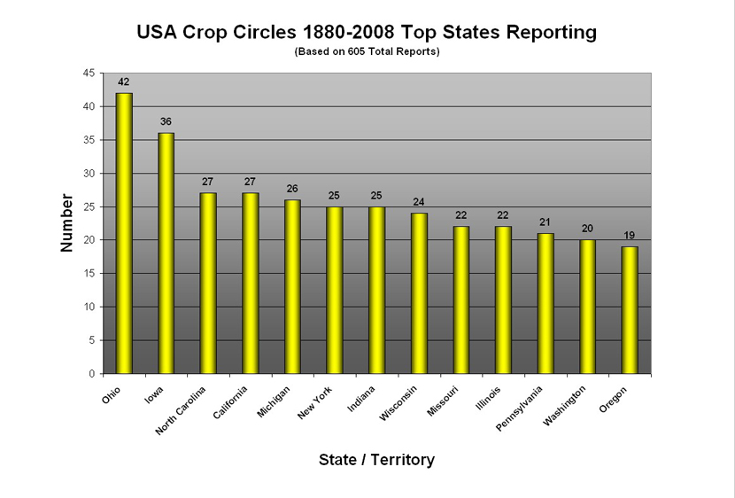
The top states in terms of the numbers of reports breaks out (or 'clusters') into only a few regions of the country:
Region 1: "Great Lakes States" - Ohio (#1), Michigan (#5), New York (#6) [the vast majority of New York reports are from the west side of the state near Lake Ontario and Lake Erie], Indiana (#7), Wisconsin (#8), Illinois (#10), Pennsylvania (#11) [again, most of the reports are from the northwest side of the state near Lake Erie]. All the states that border the Great Lakes are all among the top states reporting crop circle formations. It is also interesting to note that the province of Ontario, Canada also has reported a significant number of crop circles in the area that borders Lake Erie, Lake Ontario, and Lake St. Clair.
Region 2: "West Coast States" - The USA's west coast states of California (#4), Washington (#12), and Oregon (#13) are all among the top states reporting, and it is interesting to note that the west coast province of British Columbia, Canada has also reported a significant number of crop circle formations.
Region 3: "Central USA River Valley States" - Iowa (#2), Missouri (#9), and again including parts of Ohio (#1), Indiana (#7), Wisconsin (#8) and Illinois (#10) -- are all states which lie along the Mississippi-Ohio River Valleys and contribute a significant number of crop circle reports.
Approximately 55% of all the crop circles reported in the USA have come from just these 3 geographic regions, or these 13 states.
|


